Cime di Lemma
2348 m7703 ft
Montaña · Alpi Orobie Occidentali · Italia
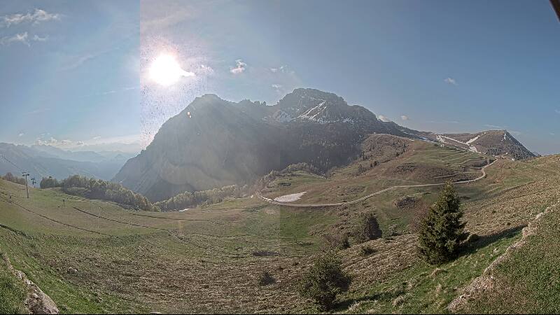
Cime di Lemma is a 2,348-metre mountain peak of Lombardy, Italy. It is located within the Bergamo Alps, near the border of the provinces of Sondrio and Bergamo in Lombardy, Italy.
De Wikipedia, CC BY-SA · Leer el artículo
En la cumbre · pronóstico para las 3:00
-2 °CNiebla · viento de 2 km/h del SE
 Verla en 3D
Clima en la cumbre de Cime di Lemma, 2348 m
- 3:00-2 °CSE 2 km/h–
- 6:00-2 °CSE 4 km/h–
- 9:003 °CE 3 km/h–
- 12:0010 °CNO 3 km/h–
- 15:009 °CO 5 km/h–
- 18:004 °CSO 3 km/h–
- 21:001 °CE 4 km/h–
- 0:00-1 °CE 4 km/h–
| Día | Cielo | Máx. / mín. | Lluvia | Viento hasta |
|---|---|---|---|---|
| Hoy | Despejado | 10 °C / -3 °C | – | 6 km/h |
| jue, 29 oct | Mayormente despejado | 7 °C / -4 °C | – | 7 km/h |
| vie, 30 oct | Mayormente despejado | 4 °C / -1 °C | – | 5 km/h |
| sáb, 31 oct | Despejado | 5 °C / -2 °C | – | 5 km/h |
| dom, 1 nov | Mayormente despejado | 2 °C / -5 °C | – | 5 km/h |
| lun, 2 nov | Mayormente despejado | 1 °C / -4 °C | – | 5 km/h |
| mar, 3 nov | Despejado | 2 °C / -7 °C | – | 5 km/h |
Pronóstico de MET Norway (CC BY 4.0), actualizado a las 02:17 CET. Horas locales.
Ficha técnica
- Tipo
- Montaña
- Altitud sobre el nivel del mar
- 2348 m (7703 ft)
- Cordillera
- Alpi Orobie Occidentali
- País
- Italia
- Coordenadas
- 46.063°N 9.709°E
- Fuente
- Wikidata, CC0
Cime di Lemma
Mountain in Italy
Cime di Lemma is a 2,348-metre mountain peak of Lombardy, Italy. It is located within the Bergamo Alps, near the border of the provinces of Sondrio and Bergamo in Lombardy, Italy. Situated above the Tartano Valley, the mountain is particularly notable as a classic and highly frequented destination for ski mountaineering in the Valtellina region.
De Wikipedia, CC BY-SA · Leer el artículo
Picos cerca de Cime di Lemma
- Monte Disgrazia3678 m · a 23 kmEn el mapa
- Pizzo Coca3052 m · a 23 kmEn el mapa
- Pizzo di Zocca3174 m · a 26 kmEn el mapa
- Cima della Bondasca3289 m · a 26 kmEn el mapa
- Cima di Castello3379 m · a 27 kmEn el mapa
- Pizzo Cengalo3369 m · a 27 kmEn el mapa
- Cima di Rosso3366 m · a 27 kmEn el mapa
- Ago di Sciora3204 m · a 27 kmEn el mapa
- Pizzo Badile3308 m · a 27 kmEn el mapa
- Cima dal Cantun3354 m · a 28 kmEn el mapa
Los más altos de Alpi Orobie Occidentali
- Pizzo Redorta3038 mEn el mapa
- Monte Masoni2663 mEn el mapa
- Monte Legnone2609 mEn el mapa
- Pizzo Tre Signori2554 mEn el mapa
- Mount Toro2524 mEn el mapa
- Monte Cadelle2483 mEn el mapa
- Monte Pegherolo2369 mEn el mapa
- Cime di Lemma2348 mEn el mapa
- Monte Cavallo2323 mEn el mapa
Montañas más altas de Italia
- Mont Blanc4806 mEn el mapa
- Liskamm4532 mEn el mapa
- Cervino4478 mEn el mapa
- Punta Walker4208 mEn el mapa
- Grandes Jorasses4208 mEn el mapa
- Dent d'Hérens4173 mEn el mapa
- Breithorn4160 mEn el mapa
- Cime di Lemma2348 mEn el mapa