Montañas de Austria
Hintere Bachofenspitze
2668 m8753 ft
Montaña · Gleirsch-Halltal Chain · Austria
The Hintere Bachofenspitze in the Karwendel mountains of Tyrol is 2,668 metres (8,753 ft) high and forms the northernmost point of the parish of Thaur in the Inn Valley. Since the erection of a summit cross, that was set up in October 2003 by Franz Brunner and Fritz Gostner, this summit has enjoyed growing popularity.
De Wikipedia, CC BY-SA · Leer el artículo
En la cumbre · pronóstico para las 10:00
1 °CNublado · viento de 7 km/h del NO
 Verla en 3D
Clima en la cumbre de Hintere Bachofenspitze, 2668 m
- 10:001 °CNO 7 km/h0,6 mm
- 13:000 °CNO 9 km/h3,3 mm
- 16:00-2 °CNO 7 km/h0,9 mm
- 19:00-3 °CN 7 km/h0,7 mm
- 22:00-4 °CN 7 km/h0,1 mm
- 1:00-4 °CN 4 km/h–
- 4:00-4 °CNE 3 km/h–
- 7:00-5 °CE 4 km/h–
| Día | Cielo | Máx. / mín. | Lluvia | Viento hasta |
|---|---|---|---|---|
| Hoy | Nieve fuerte | 1 °C / -4 °C | 5,6 mm | 10 km/h |
| jue, 29 oct | Despejado | 0 °C / -8 °C | – | 9 km/h |
| vie, 30 oct | Despejado | 0 °C / -9 °C | – | 9 km/h |
| sáb, 31 oct | Despejado | 1 °C / -9 °C | – | 8 km/h |
| dom, 1 nov | Parcialmente nublado | -4 °C / -8 °C | – | 7 km/h |
| lun, 2 nov | Nieve | -7 °C / -9 °C | 13,1 mm | 8 km/h |
| mar, 3 nov | Nieve débil | -8 °C / -10 °C | 3,2 mm | 7 km/h |
Pronóstico de MET Norway (CC BY 4.0), actualizado a las 09:19 CET. Horas locales.
Ficha técnica
- Tipo
- Montaña
- Altitud sobre el nivel del mar
- 2668 m (8753 ft)
- Aislamiento
- a 0,7 km de un terreno más alto
- Cordillera
- Gleirsch-Halltal Chain
- País
- Austria
- Coordenadas
- 47.346°N 11.438°E
- Fuente
- Wikidata, CC0
Picos cerca de Hintere Bachofenspitze
- Hafelekarspitze2334 m · a 5,2 kmEn el mapa
- Kaltwasserkarspitze2733 m · a 6,6 kmEn el mapa
- Birkkarspitze2749 m · a 7,3 kmEn el mapa
- Nordkette2637 m · a 8,4 kmEn el mapa
- Bergisel746 m · a 11 kmEn el mapa
- Patscherkofel2246 m · a 15 kmEn el mapa
- Glungezer2677 m · a 17 kmEn el mapa
- Dreitorspitze2682 m · a 24 kmEn el mapa
- Serles2717 m · a 25 kmEn el mapa
- Lizumer Reckner2886 m · a 27 kmEn el mapa
Los más altos de Gleirsch-Halltal Chain
- Großer Bettelwurf2726 mEn el mapa
- Hintere Bachofenspitze2668 mEn el mapa
- Praxmarerkarspitzen2642 mEn el mapa
- Speckkarspitze2621 mEn el mapa
- Hundskopf2243 mEn el mapa
Montañas más altas de Austria
- Grossglockner3798 mEn el mapa
- Wildspitze3768 mEn el mapa
- Weißkugel3738 mEn el mapa
- Großvenediger3657 mEn el mapa
- Hintere Schwärze3624 mEn el mapa
- Großes Wiesbachhorn3564 mEn el mapa
- Ramolkogel3549 mEn el mapa
- Schalfkogel3537 mEn el mapa
- Watzespitze3532 mEn el mapa
- Fineilspitze3514 mEn el mapa
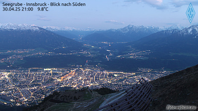
Cámaras web cerca de Hintere Bachofenspitze


Historia alrededor de Hintere Bachofenspitze
Ciudades cerca de Hintere Bachofenspitze
- Innsbrucka 9,8 km
- Telfsa 28 km
- Garmisch-Partenkirchena 30 km
- Penzberga 46 km
- Bad Tölza 47 km
- Geretsrieda 57 km