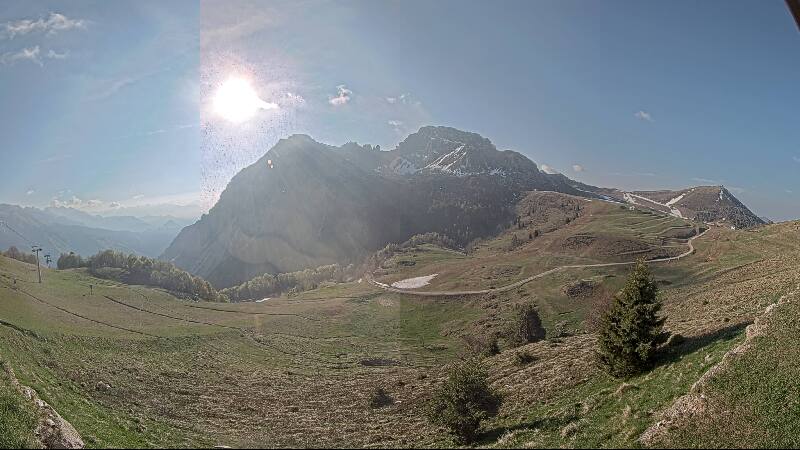
Monte Tesoro
1432 m4698 ft
Montaña · Prealpi Bergamasche Occidentali · Italia
The Monte Tesoro is a summit of the Bergamasque Prealps. It is 1,432 metres above sea level and is located in the municipality of Carenno on the mountain ridge that goes south from the Resegone towards the plains at the hills of Bergamo.
De Wikipedia, CC BY-SA · Leer el artículo
En la cumbre · pronóstico para las 4:00
2 °CDespejado · viento de 5 km/h del NE
 Verla en 3D
Clima en la cumbre de Monte Tesoro, 1432 m
- 4:002 °CNE 5 km/h–
- 7:002 °CN 4 km/h–
- 10:007 °CS 3 km/h–
- 13:009 °CS 5 km/h–
- 16:007 °CS 4 km/h–
- 19:004 °CNE 2 km/h–
- 22:003 °CNE 5 km/h–
- 1:003 °CN 4 km/h–
| Día | Cielo | Máx. / mín. | Lluvia | Viento hasta |
|---|---|---|---|---|
| Hoy | Despejado | 9 °C / 2 °C | – | 5 km/h |
| mié, 28 oct | Despejado | 9 °C / 1 °C | – | 5 km/h |
| jue, 29 oct | Despejado | 10 °C / 4 °C | – | 8 km/h |
| vie, 30 oct | Nublado | 8 °C / 3 °C | – | 4 km/h |
| sáb, 31 oct | Nublado | 8 °C / 1 °C | – | 5 km/h |
| dom, 1 nov | Mayormente despejado | 8 °C / -1 °C | – | 5 km/h |
| lun, 2 nov | Despejado | 10 °C / 2 °C | – | 4 km/h |
Pronóstico de MET Norway (CC BY 4.0), actualizado a las 02:17 CET. Horas locales.
Ficha técnica
- Tipo
- Montaña
- Altitud sobre el nivel del mar
- 1432 m (4698 ft)
- Cordillera
- Prealpi Bergamasche Occidentali
- País
- Italia
- Coordenadas
- 45.798°N 9.494°E
- Fuente
- Wikidata, CC0
Monte Tesoro
Mountain in Italy
The Monte Tesoro is a summit of the Bergamasque Prealps. It is 1,432 metres above sea level and is located in the municipality of Carenno on the mountain ridge that goes south from the Resegone towards the plains at the hills of Bergamo. It divides the valley of San Martino from the Valle Imagna between the passes of Pertus and Valcava, dividing, therefore the provinces of Lecco and Bergamo.
De Wikipedia, CC BY-SA · Leer el artículo
Picos cerca de Monte Tesoro
- Resegone1875 m · a 6,9 kmEn el mapa
- Monte Moregallo1276 m · a 14 kmEn el mapa
- Grignetta2177 m · a 16 kmEn el mapa
- Pizzo Tre Signori2554 m · a 23 kmEn el mapa
- Monte San Primo1686 m · a 26 kmEn el mapa
- Pizzo Redorta3038 m · a 27 kmEn el mapa
- Monte Legnone2609 m · a 34 kmEn el mapa
- Monte Bregagno2107 m · a 39 kmEn el mapa
- Monte Generoso1701 m · a 40 kmEn el mapa
- Presolana2521 m · a 42 kmEn el mapa
Los más altos de Prealpi Bergamasche Occidentali
- Zuccone Campelli2161 mEn el mapa
- Monte Sodadura2010 mEn el mapa
- Monte Venturosa1999 mEn el mapa
- Resegone1875 mEn el mapa
- Monte Due Mani1666 mEn el mapa
- Monte Sornadello1580 mEn el mapa
- Corno Zuccone1458 mEn el mapa
- Monte Tesoro1432 mEn el mapa
- Monte Linzone1392 mEn el mapa
Montañas más altas de Italia
- Mont Blanc4806 mEn el mapa
- Liskamm4532 mEn el mapa
- Cervino4478 mEn el mapa
- Punta Walker4208 mEn el mapa
- Grandes Jorasses4208 mEn el mapa
- Dent d'Hérens4173 mEn el mapa
- Breithorn4160 mEn el mapa
- Monte Tesoro1432 mEn el mapa