Monte Collaspro
3273 m10.738 ft
Montaña · Grupo Rieserferner · Italia
The Wildgall is, at 3,273 metres above sea level, the third highest peak in the Rieserferner Group, a range in the western part of the High Tauern. It lies within the Italian provinces of South Tyrol in the Rieserferner-Ahrn Nature Park and appears from the south as a massive pyramid with prominent arêtes.
De Wikipedia, CC BY-SA · Leer el artículo
En la cumbre · pronóstico para las 1:00
-9 °CDespejado · viento de 3 km/h del NE
 Verla en 3D
Clima en la cumbre de Monte Collaspro, 3273 m
- 1:00-9 °CNE 3 km/h–
- 4:00-7 °CN 5 km/h–
- 7:00-6 °CN 5 km/h–
- 10:00-2 °CO 4 km/h–
- 13:001 °CO 5 km/h–
- 16:00-0 °CN 5 km/h–
- 19:00-5 °CNE 6 km/h–
- 22:00-6 °CNE 5 km/h–
| Día | Cielo | Máx. / mín. | Lluvia | Viento hasta |
|---|---|---|---|---|
| Hoy | Despejado | 1 °C / -9 °C | – | 6 km/h |
| mié, 28 oct | Nublado | -1 °C / -8 °C | 0,2 mm | 8 km/h |
| jue, 29 oct | Mayormente despejado | -2 °C / -10 °C | – | 8 km/h |
| vie, 30 oct | Despejado | -2 °C / -10 °C | – | 5 km/h |
| sáb, 31 oct | Despejado | -0 °C / -9 °C | – | 4 km/h |
| dom, 1 nov | Despejado | 0 °C / -7 °C | – | 5 km/h |
| lun, 2 nov | Despejado | -2 °C / -10 °C | – | 8 km/h |
Pronóstico de MET Norway (CC BY 4.0), actualizado a las 00:19 CET. Horas locales.
Ficha técnica
- Tipo
- Montaña
- Altitud sobre el nivel del mar
- 3273 m (10.738 ft)
- Prominencia
- 292 m (958 ft)
- Aislamiento
- a 0,8 km de un terreno más alto
- Cordillera
- Grupo Rieserferner
- País
- Italia
- Coordenadas
- 46.903°N 12.135°E
- Fuente
- Wikidata, CC0
Wildgall
Mountain in Italy
The Wildgall is, at 3,273 metres above sea level, the third highest peak in the Rieserferner Group, a range in the western part of the High Tauern. It lies within the Italian provinces of South Tyrol in the Rieserferner-Ahrn Nature Park and appears from the south as a massive pyramid with prominent arêtes. It is the most difficult of the summits of the Rieserferner Group to climb.
De Wikipedia, CC BY-SA · Leer el artículo
Picos cerca de Monte Collaspro
- Hochgall3436 m · a 1,2 kmEn el mapa
- Schneebiger Nock3358 m · a 3,9 kmEn el mapa
- Rötspitze3496 m · a 15 kmEn el mapa
- Dreiherrnspitze3499 m · a 20 kmEn el mapa
- Großer Löffler3379 m · a 22 kmEn el mapa
- Kronplatz2275 m · a 23 kmEn el mapa
- Schwarzenstein3369 m · a 23 kmEn el mapa
- Großvenediger3657 m · a 28 kmEn el mapa
- Rainerhorn3559 m · a 28 kmEn el mapa
- Großer Möseler3480 m · a 29 kmEn el mapa
Los más altos de Grupo Rieserferner
- Hochgall3436 mEn el mapa
- Schneebiger Nock3358 mEn el mapa
- Monte Collaspro3273 mEn el mapa
- Lenkstein3236 mEn el mapa
- Cima del Vento3041 mEn el mapa
Montañas más altas de Italia
- Mont Blanc4806 mEn el mapa
- Liskamm4532 mEn el mapa
- Cervino4478 mEn el mapa
- Punta Walker4208 mEn el mapa
- Grandes Jorasses4208 mEn el mapa
- Dent d'Hérens4173 mEn el mapa
- Breithorn4160 mEn el mapa
- Monte Collaspro3273 mEn el mapa
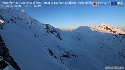
Cámaras web cerca de Monte Collaspro


Historia alrededor de Monte Collaspro
Ciudades cerca de Monte Collaspro
- Bressanonea 42 km
- Innsbrucka 69 km
- Bolzanoa 76 km
- Meranoa 79 km
- Saalfelden am Steinernen Meera 79 km