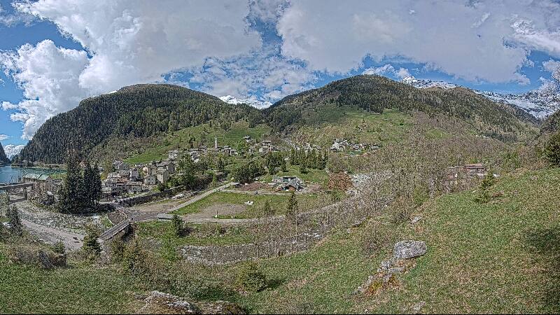
Montagnes de Suisse
Piz Por
3 028 m9 934 ft
Montagne · chaîne de l'Oberhalbstein · Suisse
Piz Por is a mountain of the Oberhalbstein Alps, located west of Innerferrera in the canton of Graubünden. It is the culminating point of the group between the Splügen Pass and the Niemet Pass.
Source : Wikipedia, CC BY-SA · Lire l’article
Au sommet · prévision pour 18:00
-4 °CBrouillard · vent 10 km/h du N
 Voir en 3D
Météo au sommet : Piz Por, 3 028 m
- 18:00-4 °CN 10 km/h–
- 21:00-5 °CN 9 km/h–
- 0:00-6 °CNE 9 km/h–
- 3:00-7 °CNE 9 km/h–
- 6:00-8 °CN 7 km/h–
- 9:00-3 °CN 5 km/h–
- 12:001 °CN 5 km/h–
- 15:001 °CN 8 km/h–
| Jour | Ciel | Max. / min. | Pluie | Vent jusqu’à |
|---|---|---|---|---|
| jeu. 29 oct. | Dégagé | 1 °C / -8 °C | – | 9 km/h |
| ven. 30 oct. | Dégagé | -0 °C / -7 °C | – | 7 km/h |
| sam. 31 oct. | Dégagé | -1 °C / -8 °C | – | 9 km/h |
| dim. 1 nov. | Plutôt dégagé | -6 °C / -11 °C | 0,3 mm | 13 km/h |
| lun. 2 nov. | Partiellement nuageux | -5 °C / -12 °C | – | 8 km/h |
| mar. 3 nov. | Dégagé | -3 °C / -11 °C | – | 8 km/h |
| mer. 4 nov. | Partiellement nuageux | -3 °C / -9 °C | 1 mm | 6 km/h |
Prévisions de MET Norway (CC BY 4.0), mises à jour à 14:17 UTC+1. Heures locales.
Fiche technique
- Type
- Montagne
- Altitude
- 3 028 m (9 934 ft)
- Proéminence
- 733 m (2 405 ft)
- Massif
- chaîne de l'Oberhalbstein
- Sommet parent
- Piz Platta
- Pays
- Suisse
- Coordonnées
- 46.509°N 9.384°E
- Source
- Wikidata, CC0
Sommets près de Piz Por
- Alperschällihorn3 036 m · à 10 kmSur la carte
- Piz Platta3 392 m · à 14 kmSur la carte
- Bruschghorn3 056 m · à 15 kmSur la carte
- Piz Beverin2 998 m · à 16 kmSur la carte
- Piz Duan3 131 m · à 21 kmSur la carte
- Piz Calderas3 397 m · à 24 kmSur la carte
- Rheinwaldhorn3 402 m · à 26 kmSur la carte
- Piz Ela3 339 m · à 27 kmSur la carte
- Pizzo Badile3 308 m · à 29 kmSur la carte
- Piz Julier3 380 m · à 29 kmSur la carte
Sommet parent
Le sommet plus haut le plus proche, auquel se mesure sa proéminence.
- Piz Platta3 392 mSur la carte
Sommets sous Piz Por
- Surettahorn3 027 mSur la carte
Les plus hauts : chaîne de l'Oberhalbstein
- Piz Platta3 392 mSur la carte
- Piz Forbesch3 262 mSur la carte
- Piz Timun3 209 mSur la carte
- Piz Duan3 131 mSur la carte
- Gletscherhorn3 107 mSur la carte
- Pizz Gallagiun3 107 mSur la carte
- Cima da Lägh3 083 mSur la carte
- Piz Grisch3 062 mSur la carte
- Piz Por3 028 mSur la carte
Plus hautes montagnes : Suisse
- pointe Dufour4 634 mSur la carte
- Dom4 546 mSur la carte
- Liskamm4 532 mSur la carte
- Weisshorn4 505 mSur la carte
- Cervin4 478 mSur la carte
- dent Blanche4 357 mSur la carte
- Grand Combin4 309 mSur la carte
- Finsteraarhorn4 274 mSur la carte
- Zinalrothorn4 221 mSur la carte
- Alphubel4 206 mSur la carte