Kaltwasserkarspitze
2.733 m8.967 pés
Montanha · Hinterautal-Vomper Chain · Áustria
The Kaltwasserkarspitze is a mountain in the Hinterautal-Vomper Chain and, at 2,733 m (AA) m, is the fourth highest peak in the Karwendel mountains in Austria after the Birkkarspitze, Middle and Eastern Ödkarspitze.
Da Wikipedia, CC BY-SA · Ler o artigo
No cume · previsão para 4:00
-2 °CParcialmente nublado · vento de 7 km/h de N
 Ver em 3D
Clima no cume de Kaltwasserkarspitze, 2.733 m
- 4:00-2 °CN 7 km/h–
- 7:00-3 °CN 5 km/h–
- 10:000 °CO 4 km/h0,8 mm
- 13:000 °CNO 9 km/h4,6 mm
- 16:00-2 °CN 9 km/h0,7 mm
- 19:00-3 °CN 7 km/h0,8 mm
- 22:00-4 °CN 4 km/h–
- 1:00-4 °CN 4 km/h–
| Dia | Céu | Máx. / mín. | Chuva | Vento até |
|---|---|---|---|---|
| Hoje | Neve forte | 2 °C / -4 °C | 6,9 mm | 9 km/h |
| qui., 29 de out. | Céu limpo | 0 °C / -7 °C | – | 8 km/h |
| sex., 30 de out. | Céu limpo | 0 °C / -9 °C | – | 8 km/h |
| sáb., 31 de out. | Céu limpo | 1 °C / -10 °C | – | 8 km/h |
| dom., 1 de nov. | Parcialmente nublado | -4 °C / -8 °C | – | 7 km/h |
| seg., 2 de nov. | Neve | -8 °C / -10 °C | 13,1 mm | 8 km/h |
| ter., 3 de nov. | Neve fraca | -8 °C / -11 °C | 3,2 mm | 7 km/h |
Previsão: MET Norway (CC BY 4.0), atualizada às 00:18 GMT+1. Horários locais.
Ficha técnica
- Tipo
- Montanha
- Altitude acima do nível do mar
- 2.733 m (8.967 pés)
- Isolamento
- a 1,3 km de um terreno mais alto
- Cordilheira
- Hinterautal-Vomper Chain
- País
- Áustria
- Coordenadas
- 47.404°N 11.454°E
- Fonte
- Wikidata, CC0
Kaltwasserkarspitze
Mountain in Austria
The Kaltwasserkarspitze is a mountain in the Hinterautal-Vomper Chain and, at 2,733 m (AA) m, is the fourth highest peak in the Karwendel mountains in Austria after the Birkkarspitze, Middle and Eastern Ödkarspitze. The Kaltwasserkarspitze is the eastern neighbour of the Birkkarspitze, its rugged summit dropping in a steep rock face to the valley of Kleiner Ahornboden.
Da Wikipedia, CC BY-SA · Ler o artigo
Picos perto de Kaltwasserkarspitze
- Birkkarspitze2.749 m · a 1,5 kmNo mapa
- Hafelekarspitze2.334 m · a 11 kmNo mapa
- Nordkette2.637 m · a 14 kmNo mapa
- Bergisel746 m · a 18 kmNo mapa
- Patscherkofel2.246 m · a 22 kmNo mapa
- Glungezer2.677 m · a 22 kmNo mapa
- Hochiss2.299 m · a 24 kmNo mapa
- Dreitorspitze2.682 m · a 25 kmNo mapa
- Krotenkopf2.086 m · a 25 kmNo mapa
- Herzogstand1.731 m · a 26 kmNo mapa
Os mais altos de Hinterautal-Vomper Chain
- Kaltwasserkarspitze2.733 mNo mapa
- Große Seekarspitze2.677 mNo mapa
- Pleisenspitze2.569 mNo mapa
- Hochnissl2.547 mNo mapa
Montanhas mais altas de Áustria
- Grossglockner3.798 mNo mapa
- Wildspitze3.768 mNo mapa
- Weißkugel3.738 mNo mapa
- Großvenediger3.657 mNo mapa
- Hintere Schwärze3.624 mNo mapa
- Großes Wiesbachhorn3.564 mNo mapa
- Ramolkogel3.549 mNo mapa
- Schalfkogel3.537 mNo mapa
- Watzespitze3.532 mNo mapa
- Fineilspitze3.514 mNo mapa
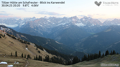
Webcams perto de Kaltwasserkarspitze


História ao redor de Kaltwasserkarspitze
Cidades perto de Kaltwasserkarspitze
- Innsbrucka 16 km
- Garmisch-Partenkirchena 29 km
- Telfsa 31 km
- Penzberga 39 km
- Bad Tölza 41 km
- Geretsrieda 51 km