Kronberg Tal, live
Kronberg Tal, Germany on TAKIP’s live map: one public camera.
Right now · as of
- No lightning within 50 km of Kronberg Tal in the last 15 minutes. Rain or snow on radar 9 km NW of Kronberg Tal.
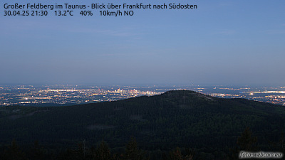
The latest from cameras in Kronberg Tal
Kronberg Tal on the map
- Kronberg Tal right nowWarnings, earthquakes, fires, lightning and rain around Kronberg Tal now
- Live cameras in Kronberg TalOne camera on the map.
- Flights over Kronberg Tal, liveFrankfurt Main Airport (FRA)
- Weather in Kronberg Tal: forecast and live mapA 7-day forecast, rain radar, lightning, airport reports from EDDF and ETOU and model temperature and wind.
- When to see the ISS from Kronberg TalThe next visible passes in local time; it can pass straight overhead.
- Sunrise and sunset in Kronberg TalSunrise, sunset, day length and twilight in local time, today and through the year.
Other places nearby
- Bad Homburg vor der Höhe9.7 km away · Weather and Hiking routes
- Frankfurt am Main15 km away · Right now, Things to do, Plans, Transit, Cameras, Flights, Weather, ISS passes, Sunrise and sunset and Hiking routes
- Offenbach21 km away · Right now, Cameras, Flights, Weather and Hiking routes
- Wiesbaden21 km away · Things to do, Plans, Flights, Weather, ISS passes, Sunrise and sunset and Hiking routes
- Rüsselsheim am Main22 km away · Weather and Hiking routes
- Mainz27 km away · Things to do, Plans, Flights, Weather and Hiking routes
- Hanau am Main30 km away · Weather and Hiking routes
- Weiterstadt31 km away · Cameras