Montañas de Austria
Gilfert
2506 m8222 ft
Montaña · Alpes de Tux · Austria
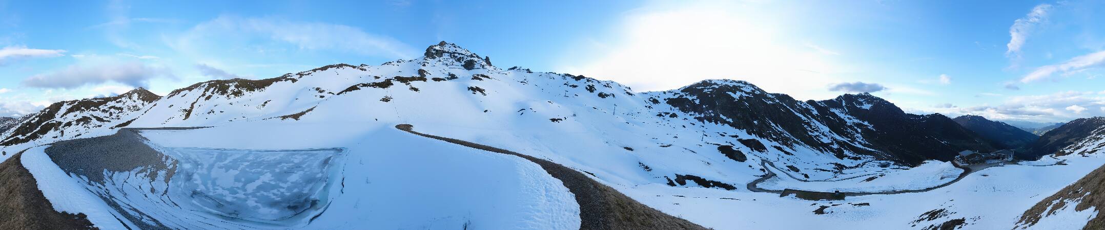
The Gilfert is a 2,506-metre-high (8,222 ft) peak in the Tux Alps. It is the most northerly extent of the Rastkogel Massif and can therefore be seen from almost anywhere in the Lower Inn Valley.
De Wikipedia, CC BY-SA · Leer el artículo
En la cumbre · pronóstico para las 1:00
-4 °CMayormente despejado · viento de 4 km/h del SO
 Verla en 3D
Clima en la cumbre de Gilfert, 2506 m
- 1:00-4 °CSO 4 km/h–
- 4:00-2 °CSO 4 km/h–
- 7:00-3 °CSO 3 km/h–
- 10:005 °CSO 3 km/h–
- 13:008 °CN 3 km/h–
- 16:007 °CNE 3 km/h–
- 19:001 °CS 3 km/h–
- 22:00-1 °CSO 4 km/h–
| Día | Cielo | Máx. / mín. | Lluvia | Viento hasta |
|---|---|---|---|---|
| Hoy | Despejado | 9 °C / -4 °C | – | 5 km/h |
| mié, 28 oct | Aguanieve | 3 °C / -3 °C | 7,3 mm | 7 km/h |
| jue, 29 oct | Mayormente despejado | 1 °C / -5 °C | 0,4 mm | 6 km/h |
| vie, 30 oct | Despejado | 1 °C / -8 °C | – | 5 km/h |
| sáb, 31 oct | Despejado | 3 °C / -10 °C | – | 4 km/h |
| dom, 1 nov | Despejado | 5 °C / -5 °C | – | 3 km/h |
| lun, 2 nov | Despejado | 0 °C / -10 °C | – | 4 km/h |
Pronóstico de MET Norway (CC BY 4.0), actualizado a las 00:19 CET. Horas locales.
Ficha técnica
- Tipo
- Montaña
- Altitud sobre el nivel del mar
- 2506 m (8222 ft)
- Prominencia
- 253 m (830 ft)
- Cordillera
- Alpes de Tux
- País
- Austria
- Coordenadas
- 47.270°N 11.743°E
- Fuente
- Wikidata, CC0
Picos cerca de Gilfert
- Rastkogel2762 m · a 7,3 kmEn el mapa
- Lizumer Reckner2886 m · a 16 kmEn el mapa
- Glungezer2677 m · a 18 kmEn el mapa
- Kreuzjoch2558 m · a 18 kmEn el mapa
- Hochiss2299 m · a 21 kmEn el mapa
- Patscherkofel2246 m · a 22 kmEn el mapa
- Olperer3476 m · a 25 kmEn el mapa
- Bergisel746 m · a 26 kmEn el mapa
- Kaltwasserkarspitze2733 m · a 26 kmEn el mapa
- Hafelekarspitze2334 m · a 28 kmEn el mapa
Los más altos de Alpes de Tux
- Lizumer Reckner2886 mEn el mapa
- Rosenjoch2796 mEn el mapa
- Rastkogel2762 mEn el mapa
- Malgrübler2749 mEn el mapa
- Hirzer2725 mEn el mapa
- Pangert2550 mEn el mapa
- Gilfert2506 mEn el mapa
- Marchkopf2499 mEn el mapa
- Mölser Berg2479 mEn el mapa
Montañas más altas de Austria
- Grossglockner3798 mEn el mapa
- Wildspitze3768 mEn el mapa
- Weißkugel3738 mEn el mapa
- Großvenediger3657 mEn el mapa
- Hintere Schwärze3624 mEn el mapa
- Großes Wiesbachhorn3564 mEn el mapa
- Ramolkogel3549 mEn el mapa
- Schalfkogel3537 mEn el mapa
- Watzespitze3532 mEn el mapa
- Fineilspitze3514 mEn el mapa
Cámaras web cerca de Gilfert



Historia alrededor de Gilfert
Ciudades cerca de Gilfert
- Innsbrucka 26 km
- Telfsa 51 km
- Garmisch-Partenkirchena 55 km
- Bad Tölza 56 km
- Penzberga 60 km
- Bressanonea 62 km