Mountains in Austria
Gilfert
2,506 m8,222 ft
Mountain · Tux Alps · Austria
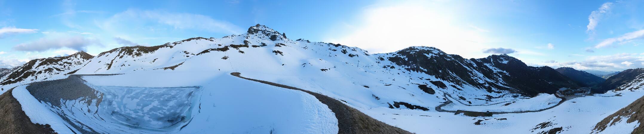
The Gilfert is a 2,506-metre-high (8,222 ft) peak in the Tux Alps. It is the most northerly extent of the Rastkogel Massif and can therefore be seen from almost anywhere in the Lower Inn Valley.
From Wikipedia, CC BY-SA · Read the article
At the summit · forecast for 12:00 AM
-4 °CClear · wind 4 km/h from the SW
 See it in 3D
Weather at the summit of Gilfert, 2,506 m
- 12:00 AM-4 °CSW 4 km/h–
- 3:00 AM-3 °CSW 4 km/h–
- 6:00 AM-2 °CSW 4 km/h–
- 9:00 AM2 °CSW 5 km/h–
- 12:00 PM8 °CNE 3 km/h–
- 3:00 PM8 °CNE 4 km/h–
- 6:00 PM2 °CSW 2 km/h–
- 9:00 PM-1 °CS 3 km/h–
| Day | Sky | High / low | Rain | Wind up to |
|---|---|---|---|---|
| Today | Clear | 9 °C / -4 °C | – | 5 km/h |
| Wed, Oct 28 | Sleet | 3 °C / -3 °C | 7.3 mm | 7 km/h |
| Thu, Oct 29 | Mostly clear | 1 °C / -4 °C | 0.4 mm | 6 km/h |
| Fri, Oct 30 | Clear | 4 °C / -7 °C | – | 4 km/h |
| Sat, Oct 31 | Clear | 4 °C / -7 °C | – | 5 km/h |
| Sun, Nov 1 | Mostly clear | 2 °C / -8 °C | – | 5 km/h |
| Mon, Nov 2 | Cloudy | -3 °C / -6 °C | 0.9 mm | 3 km/h |
Forecast by MET Norway (CC BY 4.0), updated 08:17 PM GMT+1. Times are local.
Facts
- What it is
- Mountain
- Height above sea level
- 2,506 m (8,222 ft)
- Prominence
- 253 m (830 ft)
- Range
- Tux Alps
- Country
- Austria
- Coordinates
- 47.270°N 11.743°E
- Source
- Wikidata, CC0
Peaks near Gilfert
- Rastkogel2,762 m · 7.3 km awayOn the map
- Lizumer Reckner2,886 m · 16 km awayOn the map
- Glungezer2,677 m · 18 km awayOn the map
- Kreuzjoch2,558 m · 18 km awayOn the map
- Hochiss2,299 m · 21 km awayOn the map
- Patscherkofel2,246 m · 22 km awayOn the map
- Olperer3,476 m · 25 km awayOn the map
- Bergisel746 m · 26 km awayOn the map
- Kaltwasserkarspitze2,733 m · 26 km awayOn the map
- Hafelekarspitze2,334 m · 28 km awayOn the map
Highest in the Tux Alps
- Lizumer Reckner2,886 mOn the map
- Rosenjoch2,796 mOn the map
- Rastkogel2,762 mOn the map
- Malgrübler2,749 mOn the map
- Hirzer2,725 mOn the map
- Pangert2,550 mOn the map
- Gilfert2,506 mOn the map
- Marchkopf2,499 mOn the map
- Mölser Berg2,479 mOn the map
Highest mountains in Austria
- Grossglockner3,798 mOn the map
- Wildspitze3,768 mOn the map
- Weißkugel3,738 mOn the map
- Großvenediger3,657 mOn the map
- Hintere Schwärze3,624 mOn the map
- Großes Wiesbachhorn3,564 mOn the map
- Ramolkogel3,549 mOn the map
- Schalfkogel3,537 mOn the map
- Watzespitze3,532 mOn the map
- Fineilspitze3,514 mOn the map
Webcams near Gilfert



History around Gilfert
Towns near Gilfert
- Innsbruck26 km away
- Telfs51 km away
- Garmisch-Partenkirchen55 km away
- Bad Tölz56 km away
- Penzberg60 km away
- Bressanone62 km away