 See it in 3D
Facts
- What it is
- Mountain
- Height above sea level
- 1,812 m (5,945 ft)
- Range
- Mendelkamm
- Country
- Italy
- Coordinates
- 46.296°N 11.164°E
- Source
- Wikidata, CC0
Peaks near Corno di Tres
- Rocca Piana1,873 m · 4.7 km awayOn the map
- Croz dell'Altissimo2,282 m · 22 km awayOn the map
- Grostè2,784 m · 23 km awayOn the map
- Cima Brenta3,151 m · 24 km awayOn the map
- Torre di Brenta3,014 m · 25 km awayOn the map
- Cermis2,226 m · 27 km awayOn the map
- Cima Tosa3,136 m · 27 km awayOn the map
- Latemarspitze2,800 m · 34 km awayOn the map
- Monte Bondone2,180 m · 36 km awayOn the map
- Cima d’Asta2,847 m · 37 km awayOn the map
Highest in the Mendelkamm
- Roen2,116 mOn the map
- Rocca Piana1,873 mOn the map
- Gantkofel1,866 mOn the map
- Corno di Tres1,812 mOn the map
- Penegal1,737 mOn the map
- mountain-38617841,300 mOn the map
Highest mountains in Italy
- Mont Blanc4,806 mOn the map
- Lyskamm4,532 mOn the map
- Matterhorn4,478 mOn the map
- Pointe Walker4,208 mOn the map
- Grandes Jorasses4,208 mOn the map
- Dent d'Hérens4,173 mOn the map
- Breithorn4,160 mOn the map
- Corno di Tres1,812 mOn the map
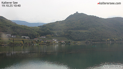
Webcams near Corno di Tres



History around Corno di Tres
Towns near Corno di Tres
- Bolzano25 km away
- Trento26 km away
- Merano41 km away
- Rovereto46 km away
- Riva del Garda52 km away
- Bressanone60 km away