Mountains in Switzerland
Gamsberg
2,385 m7,824 ft
Mountain · Appenzell Alps · Switzerland
The Gamsberg is a mountain in the Appenzell Alps, overlooking the region of Walenstadt in the canton of St. Gallen. Located in the Alvier group, it is the culminating point of the range lying between Lake Walenstadt and Toggenburg.
From Wikipedia, CC BY-SA · Read the article
The highest point of Alviergruppe
At the summit · forecast for 1:00 PM
10 °CClear · wind 4 km/h from the E
 See it in 3D
Weather at the summit of Gamsberg, 2,385 m
- 1:00 PM10 °CE 4 km/h–
- 4:00 PM9 °CN 3 km/h–
- 7:00 PM3 °CSW 3 km/h–
- 10:00 PM1 °CSW 3 km/h–
- 1:00 AM-0 °CSW 4 km/h–
- 4:00 AM-1 °CSW 3 km/h–
- 7:00 AM-1 °CSW 3 km/h–
- 10:00 AM2 °CNW 6 km/h1.3 mm
| Day | Sky | High / low | Rain | Wind up to |
|---|---|---|---|---|
| Wed, Oct 28 | Snow | 2 °C / -1 °C | 3.7 mm | 7 km/h |
| Thu, Oct 29 | Clear | 3 °C / -4 °C | – | 6 km/h |
| Fri, Oct 30 | Clear | 3 °C / -6 °C | – | 4 km/h |
| Sat, Oct 31 | Clear | 4 °C / -9 °C | – | 4 km/h |
| Sun, Nov 1 | Clear | 5 °C / -7 °C | – | 4 km/h |
| Mon, Nov 2 | Clear | 2 °C / -6 °C | – | 4 km/h |
| Tue, Nov 3 | Mostly clear | 1 °C / -7 °C | – | 4 km/h |
Forecast by MET Norway (CC BY 4.0), updated 06:20 AM GMT+1. Times are local.
Facts
- What it is
- Mountain
- Height above sea level
- 2,385 m (7,824 ft)
- Prominence
- 1,358 m (4,455 ft)
- Isolation
- 12 km to higher ground
- Range
- Appenzell Alps
- Parent peak
- Säntis
- Country
- Switzerland
- Highest point of
- Alviergruppe
- Coordinates
- 47.135°N 9.374°E
- Source
- Wikidata, CC0
Peaks near Gamsberg
- Altmann2,435 m · 12 km awayOn the map
- Säntis2,501 m · 13 km awayOn the map
- Drei Schwestern2,053 m · 16 km awayOn the map
- Falknis2,562 m · 17 km awayOn the map
- Grauspitz2,599 m · 18 km awayOn the map
- Hoher Kasten1,794 m · 18 km awayOn the map
- Galinakopf2,198 m · 19 km awayOn the map
- Naafkopf2,571 m · 19 km awayOn the map
- Pizol2,844 m · 20 km awayOn the map
- Piz Sardona3,056 m · 25 km awayOn the map
Parent peak
The nearest higher peak its prominence is measured to.
- Säntis2,501 mOn the map
Peaks below Gamsberg
- Fulfirst2,384 mOn the map
- Alvier2,343 mOn the map
- Hinderrugg2,306 mOn the map
- Speer1,951 mOn the map
- Gonzen1,830 mOn the map
Highest in the Appenzell Alps
- Säntis2,501 mOn the map
- Gamsberg2,385 mOn the map
- Furgglenfirst1,951 mOn the map
- Speer1,951 mOn the map
- Mattstock1,937 mOn the map
- Stockberg1,782 mOn the map
- Kronberg1,663 mOn the map
- Tweralpspitz1,331 mOn the map
Highest mountains in Switzerland
- Dufourspitze4,634 mOn the map
- Dom4,546 mOn the map
- Lyskamm4,532 mOn the map
- Weisshorn4,505 mOn the map
- Matterhorn4,478 mOn the map
- Dent Blanche4,357 mOn the map
- Grand Combin4,309 mOn the map
- Finsteraarhorn4,274 mOn the map
- Zinalrothorn4,221 mOn the map
- Alphubel4,206 mOn the map
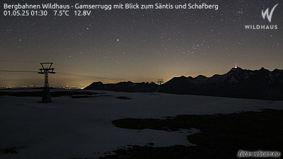
Webcams near Gamsberg


History around Gamsberg
- Battle of Ragaz1446
- The home and office of Klaus Zumwinkel, CEO of Deutsche Post, is searched by police investigating tax evasion2008
- Helikopterunfall Schwägalp1982
- Vaduz Convention1960
- The 1939 Liechtenstein putsch takes place; members of the (VDBL) unsuccessfully attempt to provoke a clash with the Liechtenstein government with the aim…1939
- Rotter kidnapping1933
- November 1918 Liechtenstein putsch1918
- Siege of Sargans1445