Mount Redoubt
10,197 ft3,108 m
Volcano · Chigmit Mountains · United States
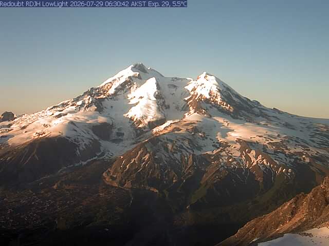
Redoubt Volcano, or Mount Redoubt, is an active stratovolcano in the largely volcanic Aleutian Range of the U.S. state of Alaska.
From Wikipedia, CC BY-SA · Read the article
The highest point of Aleutian Range
At the summit · forecast for 8:00 PM
3 °FClear · wind 2 mph from the NW
 See it in 3D
Weather at the summit of Mount Redoubt, 10,197 ft
- 8:00 PM3 °FNW 2 mph–
- 11:00 PM1 °FNW 3 mph–
- 2:00 AM1 °FNW 3 mph–
- 5:00 AM-0 °FNW 3 mph–
- 8:00 AM-3 °FW 3 mph–
- 11:00 AM1 °FSW 3 mph–
- 2:00 PM6 °FSE 3 mph0.01 in
- 5:00 PM6 °FS 4 mph0.11 in
| Day | Sky | High / low | Rain | Wind up to |
|---|---|---|---|---|
| Wed, Oct 28 | Fog | 7 °F / -3 °F | 0.31 in | 4 mph |
| Thu, Oct 29 | Heavy snow | 8 °F / 7 °F | 1.43 in | 5 mph |
| Fri, Oct 30 | Cloudy | 9 °F / 4 °F | 1.85 in | 5 mph |
| Sat, Oct 31 | Snow | 5 °F / 2 °F | 0.39 in | 2 mph |
| Sun, Nov 1 | Mostly clear | 1 °F / -5 °F | 0.05 in | 3 mph |
| Mon, Nov 2 | Heavy snow | 4 °F / -0 °F | 1.05 in | 4 mph |
| Tue, Nov 3 | Snow | 5 °F / 2 °F | 1.22 in | 6 mph |
Forecast by MET Norway (CC BY 4.0), updated 11:17 AM AKDT. Times are local.
Facts
- What it is
- Volcano
- Height above sea level
- 10,197 ft (3,108 m)
- Prominence
- 9,098 ft (2,773 m)
- Isolation
- 94 km to higher ground
- Range
- Chigmit Mountains
- Country
- United States
- First ascent
- 1959
- Highest point of
- Aleutian Range
- Coordinates
- 60.485°N 152.743°W
- Volcano number
- 313030 at the Global Volcanism Program
- Source
- Wikidata, CC0
Mount Redoubt
Volcanic cone in Alaska, United States
Redoubt Volcano, or Mount Redoubt, is an active stratovolcano in the largely volcanic Aleutian Range of the U.S. state of Alaska. Located at the head of the Chigmit Mountains subrange in Lake Clark National Park and Preserve, the mountain is just west of Cook Inlet, in the Kenai Peninsula Borough about 110 miles (180 km) southwest of Anchorage.
From Wikipedia, CC BY-SA · Read the article
99 recorded eruptions
- Eruption in 2009
- Eruption in 1989
- Eruption in 1967
- Eruption in 1966
- Eruption in 1966
- Eruption in 1933
- Eruption in 1902
- Eruption in 1819
- Eruption in 1650
- Eruption in 1530
- Eruption in 1510
- Eruption in 1400
The latest 12 of 99, from the Smithsonian’s Global Volcanism Program through History.
Peaks near Mount Redoubt
- Double Peak6,735 ft · 28 km awayOn the map
- Mount Neacola9,426 ft · 50 km awayOn the map
- Mount Iliamna10,016 ft · 54 km awayOn the map
- Black PeakMountain · 44 km awayOn the map
Peaks below Mount Redoubt
- Double Peak6,735 ftOn the map
Highest in the Chigmit Mountains
- Mount Redoubt10,197 ftOn the map
- Mount Iliamna10,016 ftOn the map
- Double Peak6,735 ftOn the map
Highest mountains in United States
- Denali20,308 ftOn the map
- Mount Saint Elias18,009 ftOn the map
- Mount Foraker17,402 ftOn the map
- Mount Bona16,535 ftOn the map
- Mount Blackburn16,390 ftOn the map
- Mount Sanford16,237 ftOn the map
- Mount Vancouver15,787 ftOn the map
- Mount Churchill15,636 ftOn the map
- Mount Fairweather15,325 ftOn the map
- Mount Hubbard14,951 ftOn the map