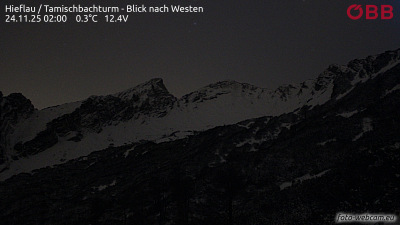
Tieflimauer
1,820 m5,971 ft
Mountain · Austria
Die Tieflimauer ist ein Berg mit einer Höhe von 1820 m ü. A. im Nationalpark Gesäuse, Ennstaler Alpen. Sie befindet sich in der Mitte des etwa 10 km langen Höhenzugs der Buchsteingruppe, die sich zwischen dem Tamischbachturm im Osten und dem Plateau des Großen Buchsteins im Westen erstreckt.
From German Wikipedia, CC BY-SA · Read the article
At the summit · forecast for 12:00 AM
-7 °CClear · wind 6 km/h from the S
 See it in 3D
Weather at the summit of Tieflimauer, 1,820 m
- 12:00 AM-7 °CS 6 km/h–
- 3:00 AM-7 °CSW 6 km/h–
- 6:00 AM-5 °CSW 5 km/h–
- 9:00 AM2 °CSW 5 km/h–
- 12:00 PM6 °CW 5 km/h–
- 3:00 PM7 °CNE 5 km/h–
- 6:00 PM2 °CS 3 km/h–
- 9:00 PM-2 °CS 6 km/h–
| Day | Sky | High / low | Rain | Wind up to |
|---|---|---|---|---|
| Today | Cloudy | 7 °C / -7 °C | – | 7 km/h |
| Wed, Oct 28 | Light rain | 8 °C / -3 °C | 1.9 mm | 14 km/h |
| Thu, Oct 29 | Cloudy | 2 °C / -1 °C | 2.1 mm | 13 km/h |
| Fri, Oct 30 | Clear | 6 °C / -5 °C | – | 5 km/h |
| Sat, Oct 31 | Cloudy | 1 °C / -5 °C | 0.7 mm | 10 km/h |
| Sun, Nov 1 | Cloudy | 0 °C / -4 °C | 0.6 mm | 8 km/h |
| Mon, Nov 2 | Partly cloudy | 1 °C / -6 °C | – | 9 km/h |
Forecast by MET Norway (CC BY 4.0), updated 08:16 PM GMT+1. Times are local.
Facts
- What it is
- Mountain
- Height above sea level
- 1,820 m (5,971 ft)
- Isolation
- 1.3 km to higher ground
- Country
- Austria
- Coordinates
- 47.626°N 14.646°E
- Source
- Wikidata, CC0
Tieflimauer
Berg im Gesäuse in der Steiermark
Die Tieflimauer ist ein Berg mit einer Höhe von 1820 m ü. A. im Nationalpark Gesäuse, Ennstaler Alpen. Sie befindet sich in der Mitte des etwa 10 km langen Höhenzugs der Buchsteingruppe, die sich zwischen dem Tamischbachturm im Osten und dem Plateau des Großen Buchsteins im Westen erstreckt. In Richtung Osten liegt zwischen der Tieflimauer und dem Tamischbachturm die Ennstaler Hütte.
From German Wikipedia, CC BY-SA · Read the article
Peaks near Tieflimauer
- Großer Buchstein2,224 m · 4.1 km awayOn the map
- Planspitze2,117 m · 5.9 km awayOn the map
- Hochtor2,369 m · 7.2 km awayOn the map
- Großer Ödstein2,335 m · 8.4 km awayOn the map
- Lugauer2,217 m · 9.9 km awayOn the map
- Admonter Reichenstein2,251 m · 12 km awayOn the map
- Sparafeld2,247 m · 12 km awayOn the map
- Kalbling2,196 m · 13 km awayOn the map
- Kaiserschild2,085 m · 17 km awayOn the map
- Scheiblingstein2,197 m · 17 km awayOn the map
Highest mountains in Austria
- Grossglockner3,798 mOn the map
- Wildspitze3,768 mOn the map
- Weißkugel3,738 mOn the map
- Großvenediger3,657 mOn the map
- Hintere Schwärze3,624 mOn the map
- Großes Wiesbachhorn3,564 mOn the map
- Ramolkogel3,549 mOn the map
- Schalfkogel3,537 mOn the map
- Watzespitze3,532 mOn the map
- Fineilspitze3,514 mOn the map