Goinger Halt
2.242 m7.356 pés
Montanha · Montes do Kaiser · Áustria
The Goinger Halt is a mountain in the Kaisergebirge range in the Northern Limestone Alps in Austria. It has a double summit: a northern top to the rear, the Hintere Goinger Halt, and a higher, southern top in front, the Vordere Goinger Halt.
Da Wikipedia, CC BY-SA · Ler o artigo
No cume · previsão para 3:00
-5 °CPoucas nuvens · vento de 4 km/h de SE
 Ver em 3D
Clima no cume de Goinger Halt, 2.242 m
- 3:00-5 °CSE 4 km/h–
- 6:00-4 °CS 4 km/h–
- 9:000 °CS 4 km/h0,6 mm
- 12:003 °CSO 8 km/h2,5 mm
- 15:001 °CNO 8 km/h2 mm
- 18:000 °CNO 8 km/h1,8 mm
- 21:00-1 °CO 5 km/h1,5 mm
- 0:00-1 °CNO 6 km/h0,2 mm
| Dia | Céu | Máx. / mín. | Chuva | Vento até |
|---|---|---|---|---|
| Hoje | Chuva com neve | 3 °C / -5 °C | 8,4 mm | 9 km/h |
| qui., 29 de out. | Parcialmente nublado | 3 °C / -4 °C | 0,4 mm | 8 km/h |
| sex., 30 de out. | Céu limpo | 2 °C / -5 °C | – | 8 km/h |
| sáb., 31 de out. | Céu limpo | 2 °C / -7 °C | – | 5 km/h |
| dom., 1 de nov. | Parcialmente nublado | 0 °C / -7 °C | – | 6 km/h |
| seg., 2 de nov. | Parcialmente nublado | -2 °C / -8 °C | 3 mm | 5 km/h |
| ter., 3 de nov. | Neve | -2 °C / -7 °C | 12,1 mm | 9 km/h |
Previsão: MET Norway (CC BY 4.0), atualizada às 20:17 GMT+1. Horários locais.
Ficha técnica
- Tipo
- Montanha
- Altitude acima do nível do mar
- 2.242 m (7.356 pés)
- Isolamento
- a 0,7 km de um terreno mais alto
- Cordilheira
- Montes do Kaiser
- País
- Áustria
- Coordenadas
- 47.564°N 12.325°E
- Fonte
- Wikidata, CC0
Goinger Halt
Mountain in Austria
The Goinger Halt is a mountain in the Kaisergebirge range in the Northern Limestone Alps in Austria. It has a double summit: a northern top to the rear, the Hintere Goinger Halt, and a higher, southern top in front, the Vordere Goinger Halt. The name "Halt" means something like Alpine meadow and refers therefore to the peak over the meadow areas, that belong to the parish of Going.
Da Wikipedia, CC BY-SA · Ler o artigo
Picos perto de Goinger Halt
- Predigtstuhl2.116 m · a 0,7 kmNo mapa
- Fleischbank2.186 m · a 0,8 kmNo mapa
- Totenkirchl2.190 m · a 1,2 kmNo mapa
- Ackerlspitze2.329 m · a 1,7 kmNo mapa
- Ellmauer Halt2.344 m · a 1,8 kmNo mapa
- Treffauer2.304 m · a 2,7 kmNo mapa
- Hackenköpfe2.126 m · a 5,3 kmNo mapa
- Petersköpfl1.745 m · a 7,7 kmNo mapa
- Naunspitze1.633 m · a 8 kmNo mapa
- Hohe Salve1.828 m · a 14 kmNo mapa
Os mais altos de Montes do Kaiser
- Ellmauer Halt2.344 mNo mapa
- Goinger Halt2.242 mNo mapa
- Hackenköpfe2.126 mNo mapa
Montanhas mais altas de Áustria
- Grossglockner3.798 mNo mapa
- Wildspitze3.768 mNo mapa
- Weißkugel3.738 mNo mapa
- Großvenediger3.657 mNo mapa
- Hintere Schwärze3.624 mNo mapa
- Großes Wiesbachhorn3.564 mNo mapa
- Ramolkogel3.549 mNo mapa
- Schalfkogel3.537 mNo mapa
- Watzespitze3.532 mNo mapa
- Fineilspitze3.514 mNo mapa
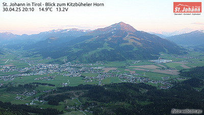
Webcams perto de Goinger Halt


História ao redor de Goinger Halt
Cidades perto de Goinger Halt
- Rosenheima 36 km
- Kolbermoora 37 km
- Bad Aiblinga 41 km
- Traunsteina 41 km
- Saalfelden am Steinernen Meera 42 km
- Bad Reichenhalla 45 km