Vordere Brandjochspitze
2.559 m8.396 ft
Dağ · Avusturya
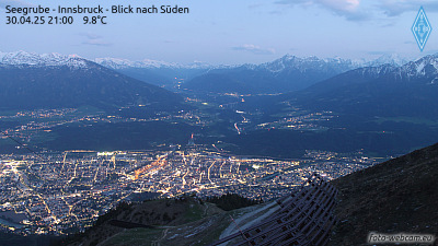
The Vordere Brandjochspitze is a peak, 2,559 m (AA) high, in the Nordkette in the Karwendel range and is one of its highest and most striking peaks. In its immediate vicinity to the north-northwest is its sister summit, the Hintere Brandjochspitze, which is about 40 metres higher.
Kaynak: Wikipedia, CC BY-SA · Makaleyi oku
Zirvede · 2:00 tahmini
-3 °CBulutlu · rüzgâr KB yönünden 4 km/sa
 3D olarak gör
Vordere Brandjochspitze zirvesinde hava durumu, 2.559 m
- 2:00-3 °CKB 4 km/sa–
- 5:00-4 °CK 3 km/sa–
- 8:00-4 °CG 4 km/sa–
- 11:00-1 °CGD 5 km/sa–
- 14:002 °CD 6 km/sa–
- 17:00-2 °CKD 4 km/sa–
- 20:00-5 °CKD 4 km/sa–
- 23:00-8 °CK 4 km/sa–
| Gün | Gökyüzü | En yüksek / en düşük | Yağmur | Maks. rüzgâr |
|---|---|---|---|---|
| Bugün | Az bulutlu | 2 °C / -8 °C | – | 7 km/sa |
| 30 Eki Cum | Açık | 3 °C / -9 °C | – | 8 km/sa |
| 31 Eki Cmt | Açık | 3 °C / -9 °C | – | 6 km/sa |
| 1 Kas Paz | Kar | -4 °C / -8 °C | 1,7 mm | 8 km/sa |
| 2 Kas Pzt | Parçalı bulutlu | -5 °C / -8 °C | – | 4 km/sa |
| 3 Kas Sal | Bulutlu | -5 °C / -8 °C | 0,3 mm | 4 km/sa |
| 4 Kas Çar | Açık | 2 °C / -12 °C | 0,1 mm | 4 km/sa |
Tahmin: MET Norway (CC BY 4.0), güncelleme 20:20 GMT+1. Saatler yerel saattir.
Temel bilgiler
- Türü
- Dağ
- Deniz seviyesinden yükseklik
- 2.559 m (8.396 ft)
- İzolasyon
- daha yüksek bir zemine 0,1 km
- Ülke
- Avusturya
- Koordinatlar
- 47.302°N 11.341°E
- Kaynak
- Wikidata, CC0
Vordere Brandjochspitze
The Vordere Brandjochspitze is a peak, 2,559 m (AA) high, in the Nordkette in the Karwendel range and is one of its highest and most striking peaks. In its immediate vicinity to the north-northwest is its sister summit, the Hintere Brandjochspitze, which is about 40 metres higher. To the south a prominent arête runs over to the Brandjochkreuz and the Achselkopf and down to the Innsbruck quarter of Hötting.
Kaynak: Wikipedia, CC BY-SA · Makaleyi oku
Vordere Brandjochspitze yakınındaki zirveler
- Nordkette2.637 m · 0,7 km uzaktaHaritada
- Bergisel746 m · 7,6 km uzaktaHaritada
- Patscherkofel2.246 m · 14 km uzaktaHaritada
- Birkkarspitze2.749 m · 14 km uzaktaHaritada
- Dreitorspitze2.682 m · 20 km uzaktaHaritada
- Serles2.717 m · 20 km uzaktaHaritada
- Hochwanner2.744 m · 24 km uzaktaHaritada
- Alpspitze2.628 m · 26 km uzaktaHaritada
- Wank1.780 m · 27 km uzaktaHaritada
- Höllentalspitzen2.743 m · 27 km uzaktaHaritada
Avusturya en yüksek dağları
- Grossglockner3.798 mHaritada
- Wildspitze3.768 mHaritada
- Weißkugel3.738 mHaritada
- Großvenediger3.657 mHaritada
- Hintere Schwärze3.624 mHaritada
- Großes Wiesbachhorn3.564 mHaritada
- Ramolkogel3.549 mHaritada
- Schalfkogel3.537 mHaritada
- Watzespitze3.532 mHaritada
- Fineilspitze3.514 mHaritada