美国的山
Dunderberg Peak
12,379 英尺3,773 米
山 · 內華達山脈 · 美国
Dunderberg Peak is located east of the Sierra Nevada crest near the divide between the Mono Basin and East Walker River basin in Mono County, in eastern California in the southwestern United States. The peak is in the Hoover Wilderness and is the highest point in Humboldt-Toiyabe National Forest.
来自Wikipedia,CC BY-SA · 阅读文章
山顶 · 16:00 的预报
37 °F多云 · 南风 5 英里/小时
 3D 查看
Dunderberg Peak山顶天气,12,379 英尺
- 16:0037 °F南 5 英里/小时–
- 19:0027 °F东南 2 英里/小时–
- 22:0023 °F南 2 英里/小时–
- 1:0021 °F南 2 英里/小时–
- 4:0023 °F西南 3 英里/小时–
- 7:0022 °F西南 3 英里/小时–
- 10:0030 °F南 8 英里/小时–
- 13:0032 °F南 11 英里/小时–
| 日期 | 天气 | 最高 / 最低 | 雨 | 最大风速 |
|---|---|---|---|---|
| 10月29日周四 | 阴 | 33 °F / 18 °F | 0.02 英寸 | 12 英里/小时 |
| 10月30日周五 | 小雪 | 28 °F / 17 °F | 0.06 英寸 | 10 英里/小时 |
| 10月31日周六 | 中雪 | 27 °F / 19 °F | 0.4 英寸 | 8 英里/小时 |
| 11月1日周日 | 晴 | 20 °F / 6 °F | 0.15 英寸 | 4 英里/小时 |
| 11月2日周一 | 多云 | 29 °F / 12 °F | – | 1 英里/小时 |
| 11月3日周二 | 阴 | 40 °F / 26 °F | – | 2 英里/小时 |
| 11月4日周三 | 阴 | 42 °F / 24 °F | – | 4 英里/小时 |
预报来自 MET Norway(CC BY 4.0),更新于 GMT-7 12:18。时间均为当地时间。
基本信息
Dunderberg Peak附近的山峰
- Excelsior Mountain12,438 英尺 · 5.2 公里外地图上
- Twin Peaks12,293 英尺 · 7.4 公里外地图上
- Whorl Mountain12,034 英尺 · 9.6 公里外地图上
- North Peak12,248 英尺 · 9.8 公里外地图上
- Matterhorn Peak12,301 英尺 · 10 公里外地图上
- 康内斯山12,649 英尺 · 12 公里外地图上
- Tioga Peak11,526 英尺 · 13 公里外地图上
- Eagle Peak11,854 英尺 · 17 公里外地图上
- 达拉山13,061 英尺 · 19 公里外地图上
- Lembert Dome9,455 英尺 · 21 公里外地图上
內華達山脈最高峰
- 惠特尼峰14,505 英尺地图上
- 威廉森山14,403 英尺地图上
- Mount Russell14,094 英尺地图上
- Mount Langley14,032 英尺地图上
- Mount Tyndall14,025 英尺地图上
- Mount Humphreys13,992 英尺地图上
- Mount Keith13,982 英尺地图上
- Mount LeConte13,936 英尺地图上
- Dunderberg Peak12,379 英尺地图上
美国最高的山
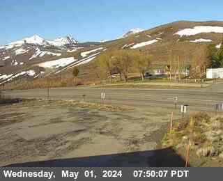
Dunderberg Peak附近的网络摄像头


Dunderberg Peak附近的城镇
- Mammoth Lakes55 公里外