Neureuth
1,261 m4,137 ft
山 · Schliersee Mountains · ドイツ
The Neureuth is a 1,261-metre-high (4,137 ft) mountain in the Bavarian Prealps east of Lake Tegernsee in Bavaria, Germany. It is a popular destination for the citizens of Munich. The summit with the much-visited Neureuth Inn can be reached by an easy hike from the town Tegernsee or from the village Gasse.
出典: Wikipedia、CC BY-SA · 記事を読む
山頂 · 1:00 の予報
4 °C晴れ時々曇り · 南の風 3 km/h
 3D で見る
Neureuth 山頂の天気(1,261 m)
- 1:004 °C南 3 km/h–
- 4:008 °C南西 4 km/h–
- 7:006 °C南東 3 km/h–
- 10:0013 °C南東 5 km/h–
- 13:0015 °C北東 8 km/h–
- 16:0013 °C北東 7 km/h–
- 19:008 °C南 4 km/h–
- 22:009 °C南西 8 km/h–
| 日付 | 天気 | 最高 / 最低 | 雨 | 最大風速 |
|---|---|---|---|---|
| 今日 | 快晴 | 15 °C / 4 °C | – | 10 km/h |
| 10月28日(水) | 強い雨 | 9 °C / 4 °C | 5 mm | 15 km/h |
| 10月29日(木) | 晴れ | 7 °C / 2 °C | – | 13 km/h |
| 10月30日(金) | 快晴 | 8 °C / 1 °C | – | 6 km/h |
| 10月31日(土) | 快晴 | 7 °C / 0 °C | – | 6 km/h |
| 11月1日(日) | 晴れ時々曇り | 5 °C / -0 °C | – | 5 km/h |
| 11月2日(月) | 曇り | 3 °C / 1 °C | – | 4 km/h |
MET Norway(CC BY 4.0)による予報。20:16 GMT+1 更新。時刻は現地時間です。
基本データ
- 種類
- 山
- 標高
- 1,261 m (4,137 ft)
- 山脈
- Schliersee Mountains
- 国
- ドイツ
- 座標
- 47.728°N 11.772°E
Neureuth (mountain)
Mountain in Bavaria, Germany
The Neureuth is a 1,261-metre-high (4,137 ft) mountain in the Bavarian Prealps east of Lake Tegernsee in Bavaria, Germany. It is a popular destination for the citizens of Munich. The summit with the much-visited Neureuth Inn can be reached by an easy hike from the town Tegernsee or from the village Gasse. Even in winter the Neureuth is accessible without special equipment. The Neureuth Inn operates all year round.
出典: Wikipedia、CC BY-SA · 記事を読む
Neureuth周辺の山
- Wallberg1,722 m · 7.1 km先地図上
- Aiplspitz1,759 m · 13 km先地図上
- Rotwand1,884 m · 15 km先地図上
- ヴェンデルシュタイン山1,838 m · 18 km先地図上
- Benediktenwand1,801 m · 24 km先地図上
- Hochiss2,299 m · 30 km先地図上
- Mondscheinspitze2,106 m · 31 km先地図上
- Jochberg1,565 m · 32 km先地図上
- Osterseen591 m · 36 km先地図上
- Herzogstand1,731 m · 37 km先地図上
Schliersee Mountainsの最高峰
- Rotwand1,884 m地図上
- Großer Traithen1,852 m地図上
- ヴェンデルシュタイン山1,838 m地図上
- Trainsjoch1,708 m地図上
- Brecherspitz1,683 m地図上
- Bodenschneid1,668 m地図上
- Brünnstein1,634 m地図上
- Schmaleggerjoch1,633 m地図上
- Neureuth1,261 m地図上
ドイツの高い山
- ツークシュピッツェ2,962 m地図上
- Hochwanner2,744 m地図上
- Dreitorspitze2,682 m地図上
- ホッホカルター2,607 m地図上
- Biberkopf2,599 m地図上
- Großer Hundstod2,594 m地図上
- Hochvogel2,592 m地図上
- Östliche Karwendelspitze2,538 m地図上
- Hocheisspitze2,523 m地図上
- Hoher Göll2,522 m地図上
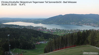
Neureuth周辺のライブカメラ


Neureuth周辺の歴史
Neureuth周辺の町
- Bad Tölz16 km先
- Holzkirchen17 km先
- Bruckmühl20 km先
- Bad Aibling23 km先
- Kolbermoor26 km先
- Geretsried26 km先