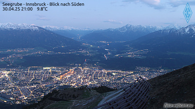
ノルトケッテ
2,637 m8,652 ft
山 · カルヴェンデル · オーストリア
The Nordkette, also variously called the North Chain, Northern Range, rarely the Inn Valley Range or Inn Valley Chain (Inntalkette), is a range of mountains just north of the city of Innsbruck in Austria. It is the southernmost of the four great mountain chains in the Karwendel.
出典: Wikipedia、CC BY-SA · 記事を読む
山頂 · 6:00 の予報
-4 °C曇り · 北東の風 2 km/h
 3D で見る
ノルトケッテ 山頂の天気(2,637 m)
- 6:00-4 °C北東 2 km/h–
- 9:000 °C北東 3 km/h–
- 12:006 °C南西 3 km/h–
- 15:008 °C南西 3 km/h–
- 18:002 °C北東 2 km/h–
- 21:00-1 °C北東 3 km/h–
- 0:00-3 °C北東 3 km/h–
- 3:00-4 °C北東 4 km/h–
| 日付 | 天気 | 最高 / 最低 | 雨 | 最大風速 |
|---|---|---|---|---|
| 今日 | 快晴 | 8 °C / -4 °C | – | 4 km/h |
| 10月28日(水) | 雪 | 2 °C / -4 °C | 4.7 mm | 9 km/h |
| 10月29日(木) | 晴れ | 1 °C / -5 °C | 0.1 mm | 7 km/h |
| 10月30日(金) | 快晴 | 2 °C / -9 °C | – | 4 km/h |
| 10月31日(土) | 晴れ | 5 °C / -10 °C | – | 3 km/h |
| 11月1日(日) | 快晴 | 4 °C / -9 °C | – | 4 km/h |
| 11月2日(月) | 快晴 | 1 °C / -10 °C | – | 3 km/h |
MET Norway(CC BY 4.0)による予報。02:17 GMT+1 更新。時刻は現地時間です。
基本データ
- 種類
- 山
- 標高
- 2,637 m (8,652 ft)
- 山脈
- カルヴェンデル
- 座標
- 47.300°N 11.350°E
Nordkette
Mountain in Austria
The Nordkette, also variously called the North Chain, Northern Range, rarely the Inn Valley Range or Inn Valley Chain (Inntalkette), is a range of mountains just north of the city of Innsbruck in Austria. It is the southernmost of the four great mountain chains in the Karwendel. To the west it is linked by the Erl Saddle to the Erlspitze Group, to the east via the Stempeljoch saddle to the Gleirsch-Halltal Range.
出典: Wikipedia、CC BY-SA · 記事を読む
ノルトケッテ周辺の山
- ベルクイーゼル746 m · 7 km先地図上
- Patscherkofel2,246 m · 13 km先地図上
- Birkkarspitze2,749 m · 14 km先地図上
- Serles2,717 m · 20 km先地図上
- Dreitorspitze2,682 m · 20 km先地図上
- Hochwanner2,744 m · 25 km先地図上
- Alpspitze2,628 m · 27 km先地図上
- Wank1,780 m · 28 km先地図上
- Höllentalspitzen2,743 m · 28 km先地図上
- Habicht3,277 m · 29 km先地図上
カルヴェンデルの最高峰
- Birkkarspitze2,749 m地図上
- ノルトケッテ2,637 m地図上
- Gamsjoch2,452 m地図上
- mountain-1399972362,000 m地図上
- Vorderskopf1,858 m地図上
- Zirler Berg1,057 m地図上
オーストリアの高い山
- グロースグロックナー山3,798 m地図上
- ヴィルトシュピッツェ3,768 m地図上
- ヴァイスクーゲル3,738 m地図上
- Großvenediger3,657 m地図上
- Hintere Schwärze3,624 m地図上
- Großes Wiesbachhorn3,564 m地図上
- Ramolkogel3,549 m地図上
- Schalfkogel3,537 m地図上
- ヴァッツェシュピッツェ3,532 m地図上
- フィンアイルシュピッツェ3,514 m地図上