Mountains in Austria
Einstein
1,866 m6,122 ft
Mountain · Allgäu Alps · Austria
Der Einstein ist ein Berg in den Tannheimer Bergen der Allgäuer Alpen. Er erhebt sich nördlich des Tannheimer Tals über der Ortschaft Tannheim in Tirol.
From German Wikipedia, CC BY-SA · Read the article
At the summit · forecast for 12:00 AM
3 °CMostly clear · wind 5 km/h from the S
 See it in 3D
Weather at the summit of Einstein, 1,866 m
- 12:00 AM3 °CS 5 km/h–
- 3:00 AM5 °CSW 4 km/h–
- 6:00 AM4 °CS 4 km/h–
- 9:00 AM9 °CSE 6 km/h–
- 12:00 PM13 °CN 5 km/h–
- 3:00 PM12 °CN 6 km/h–
- 6:00 PM6 °CS 4 km/h–
- 9:00 PM4 °CS 8 km/h–
| Day | Sky | High / low | Rain | Wind up to |
|---|---|---|---|---|
| Tue, Oct 27 | Clear | 13 °C / 3 °C | – | 10 km/h |
| Wed, Oct 28 | Rain | 5 °C / 1 °C | 3.5 mm | 12 km/h |
| Thu, Oct 29 | Clear | 5 °C / -1 °C | – | 13 km/h |
| Fri, Oct 30 | Clear | 7 °C / -1 °C | – | 5 km/h |
| Sat, Oct 31 | Clear | 7 °C / -1 °C | – | 5 km/h |
| Sun, Nov 1 | Cloudy | 5 °C / -0 °C | – | 6 km/h |
| Mon, Nov 2 | Partly cloudy | 2 °C / -2 °C | – | 6 km/h |
Forecast by MET Norway (CC BY 4.0), updated 08:17 PM GMT+1. Times are local.
Facts
- What it is
- Mountain
- Height above sea level
- 1,866 m (6,122 ft)
- Prominence
- 721 m (2,365 ft)
- Isolation
- 3.5 km to higher ground
- Range
- Allgäu Alps
- Parent peak
- Sefenspitze
- Country
- Austria
- Coordinates
- 47.522°N 10.514°E
- Source
- Wikidata, CC0
Peaks near Einstein
- Ponten2,044 m · 6.2 km awayOn the map
- Gaishorn2,247 m · 6.5 km awayOn the map
- Kühgundkopf1,907 m · 6.5 km awayOn the map
- B'schießer1,998 m · 6.7 km awayOn the map
- Rote Flüh2,108 m · 7.6 km awayOn the map
- Gimpel2,173 m · 7.8 km awayOn the map
- Rauhhorn2,241 m · 7.9 km awayOn the map
- Kugelhorn2,125 m · 8.8 km awayOn the map
- Kellenspitze2,238 m · 9.1 km awayOn the map
- Leilachspitze2,274 m · 9.6 km awayOn the map
Parent peak
The nearest higher peak its prominence is measured to.
- Sefenspitze1,948 mOn the map
Peaks below Einstein
- Schönkahler1,688 mOn the map
Highest in the Allgäu Alps
- Krottenkopf2,656 mOn the map
- Hohes Licht2,651 mOn the map
- Biberkopf2,599 mOn the map
- Hochvogel2,592 mOn the map
- Widderstein2,533 mOn the map
- Einstein1,866 mOn the map
Highest mountains in Austria
- Grossglockner3,798 mOn the map
- Wildspitze3,768 mOn the map
- Weißkugel3,738 mOn the map
- Großvenediger3,657 mOn the map
- Hintere Schwärze3,624 mOn the map
- Großes Wiesbachhorn3,564 mOn the map
- Ramolkogel3,549 mOn the map
- Schalfkogel3,537 mOn the map
- Watzespitze3,532 mOn the map
- Fineilspitze3,514 mOn the map
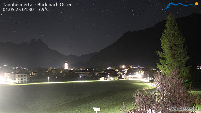
Webcams near Einstein



History around Einstein
- Treaty of Füssen1745
Towns near Einstein
- Füssen15 km away
- Sonthofen17 km away
- Kempten (Allgäu)27 km away
- Marktoberdorf30 km away
- Kaufbeuren41 km away
- Garmisch-Partenkirchen44 km away