Kehlstein
1.881 m6.171 pés
Montanha · Göll · Alemanha
The Kehlstein is a 1,881 m (6,171 ft) subpeak of the Göll massif, a 2,522 m (8,274 ft) mountain in the Berchtesgaden Alps. The rocky promontory is located west of the Hoher Göll main summit, high above the Obersalzberg mountain retreat near Berchtesgaden.
Da Wikipedia, CC BY-SA · Ler o artigo
No cume · previsão para 2:00
-1 °CCéu limpo · vento de 10 km/h de S
 Ver em 3D
Clima no cume de Kehlstein, 1.881 m
- 2:00-1 °CS 10 km/h–
- 5:002 °CS 9 km/h–
- 8:003 °CS 8 km/h–
- 11:008 °CL 5 km/h–
- 14:0010 °CNE 5 km/h–
- 17:005 °CSO 1 km/h–
- 20:002 °CS 8 km/h–
- 23:002 °CS 5 km/h–
| Dia | Céu | Máx. / mín. | Chuva | Vento até |
|---|---|---|---|---|
| Hoje | Céu limpo | 10 °C / -1 °C | – | 10 km/h |
| qua., 28 de out. | Chuva | 7 °C / 0 °C | 9,8 mm | 12 km/h |
| qui., 29 de out. | Nublado | 3 °C / -2 °C | 0,2 mm | 5 km/h |
| sex., 30 de out. | Céu limpo | 4 °C / -4 °C | – | 6 km/h |
| sáb., 31 de out. | Céu limpo | 6 °C / -3 °C | – | 6 km/h |
| dom., 1 de nov. | Céu limpo | 7 °C / -2 °C | – | 5 km/h |
| seg., 2 de nov. | Poucas nuvens | 3 °C / -4 °C | – | 5 km/h |
Previsão: MET Norway (CC BY 4.0), atualizada às 00:19 GMT+1. Horários locais.
Ficha técnica
- Tipo
- Montanha
- Altitude acima do nível do mar
- 1.881 m (6.171 pés)
- Cordilheira
- Göll
- País
- Alemanha
- Coordenadas
- 47.610°N 13.046°E
- Fonte
- Wikidata, CC0
Kehlstein
Mountain in the Berchtesgaden Alps, near the Austrian-German border
The Kehlstein is a 1,881 m (6,171 ft) subpeak of the Göll massif, a 2,522 m (8,274 ft) mountain in the Berchtesgaden Alps. The rocky promontory is located west of the Hoher Göll main summit, high above the Obersalzberg mountain retreat near Berchtesgaden. It is chiefly known for the Kehlsteinhaus mountain inn built in 1937–1938, which today is a major tourist destination.
Da Wikipedia, CC BY-SA · Ler o artigo
Picos perto de Kehlstein
- Hoher Göll2.522 m · a 2,3 kmNo mapa
- Berchtesgadener Hochthron1.972 m · a 10 kmNo mapa
- Hochkalter2.607 m · a 14 kmNo mapa
- Karkopf1.738 m · a 14 kmNo mapa
- Grießkogel2.543 m · a 16 kmNo mapa
- Grosser Hundstod2.594 m · a 16 kmNo mapa
- Schottmalhorn1.982 m · a 16 kmNo mapa
- Raucheck2.430 m · a 18 kmNo mapa
- Schönfeldspitze2.653 m · a 19 kmNo mapa
- Stadelhorn2.286 m · a 19 kmNo mapa
Os mais altos de Göll
- Hoher Göll2.522 mNo mapa
- Hinteres Freieck2.308 mNo mapa
- Kehlstein1.881 mNo mapa
- Jenner1.874 mNo mapa
Montanhas mais altas de Alemanha
- Zugspitze2.962 mNo mapa
- Hochwanner2.744 mNo mapa
- Dreitorspitze2.682 mNo mapa
- Hochkalter2.607 mNo mapa
- Biberkopf2.599 mNo mapa
- Grosser Hundstod2.594 mNo mapa
- Hochvogel2.592 mNo mapa
- Östliche Karwendelspitze2.538 mNo mapa
- Hocheisspitze2.523 mNo mapa
- Hoher Göll2.522 mNo mapa
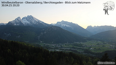
Webcams perto de Kehlstein



História ao redor de Kehlstein
Cidades perto de Kehlstein
- Bad Reichenhalla 18 km
- Salzburga 21 km
- Saalfelden am Steinernen Meera 25 km
- Freilassinga 26 km
- Traunsteina 42 km
- Traunreuta 52 km